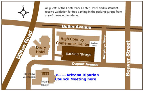
The 28th Meeting of the Arizona Riparian Council will be held October 15-16, 2015 in the 1899 Ballroom, High Country Conference Center, Flagstaff, Arizona and is cosponsored by the School of Forestry, Northern Arizona University and the Soil and Water Conservation Society. The theme of this year’s meeting is Tools and Techniques for Assessing and Restoring Riparian Habitat. On Thursday morning, invited speakers will share their expertise in the tools they are using to understand riparian ecology, genetic approaches to restoration, monitoring irrigation and soil properties, and LIDAR imagery to assess habitat suitability. These presentations will be followed by submitted technical papers and posters. Friday will be a field trip to Rio de Flag located within the Flagstaff city limits.
Keep an eye on the weather!!!
For all you that are registered for the Arizona Riparian Council’s annual meeting this Thursday and Friday, it looks like fall weather is coming! There is a chance of rain on Thursday and Friday in Flagstaff. We will be indoors for the meeting on Thursday. However we will need to walk outside to get to the area where we will be having lunch.
On Friday we will be outside at Picture Canyon and Rio de Flag. The temps may be in the 60’s and it may rain. Dress accordingly.
I will see you on Thursday.
Kris Randall, President
- Final Program
- Call for Papers
- Registration
- Preliminary Program, Thursday, October 15
- Field Trip and Demonstration, Friday, October 16
- Some Hotels in the Area
Call for Papers and Posters
Individuals are invited to submit abstracts for a technical presentation or a poster session on tools and techniques used to assess riparian habitats. Other riparian related abstracts will be considered. Call for papers and posters — deadline Friday, August 28, 2015.
Registration
Register through Paypal or by printing the form and mailing in your check.
Preliminary Program, Thursday
7:45 -8:30 a.m. Registration
8:30 – 9:00 a.m. Welcome and Goals and Objectives of Meeting
- Kris Randall, President
- Kevin Grady, Assistant Research Professor, School of Foestry, Northern Arizona University
- Gary Wendt, Treasurer, Soil and Water Conservation Society, Arizona Chapter
9:00-9:45 a.m. – Daniel Allen, Assistant Professor, College of Letters and Sciences, Arizona State University, Polytechnic campus – Wet/Dry Mapping, ER Sensors, and SWAT Models: Hydrological Tools to Better Understand River Drying Patterns at Different Temporal and Spatial Scales
9:45-10:30 a.m. – Matthew Grabau, Restoration Scientist, GeoSystems Analysis, Inc., Tucson – Soil Moisture Monitoring to Inform Riparian Restoration, Monitoring, and Research Projects
10:30-10:45 a.m. Break
10:45 – 11:30 a.m. – Bruce Orr, Senior Scientist, Stillwater Sciences, Portland – A Restoration Framework for the Upper Gila River, Arizona
11:30 a.m. – 12:15 p.m. – Tom Whitman, Regents’ Professor, Biological Sciences & Merriam Powell Center for Environmental Research, Northern Arizona University – The Reality of Climate Change and the Need for Genetics Approaches in Riparian Restoration
12:15 – 1:30 p.m. Lunch
1:30 – 1:50 p.m. – Anna V. Schrenk and Calvin Rogers, The Use of Tablet Computers for Field Data Collection in the Verde River Watershed
1:50 – 2:10 p.m. – Lindsey Bunting, Matt Grabau, Mike Milczarek, Barbara Raulston, Bill De Vor, and Francisco Zamora, Direct Seeding and Seedling Production as a Tool for Restoring Riparian Habitats
2:10 – 2:30 p.m. – Shawn Stone, J. Johnson, G. Leverich, and R. More Hla, Zonal Planting Methodologies for Restoration on the Upper Gila River
2:30 – 2:50 p.m. – Allen Haden, Use of the “Bank Assessment for Non-point Source Consequences of Sediment” (BANCS) model for predicting stream bank stability and sediment influx to streams
2:50 – 3:10 p.m. – Break
3:10 – 3:30 p.m. – Katie Junghans, Abe Springer, Larry Stevens, and James Allen, Estimating Springs Density in Death Valley National Park
3:30 – 3:50 p.m. – Jeri Ledbetter, Larry Stevens, and Abe Springer, Springs Online: A Secure, Collaborative Tool to Enter, Analyze, and Retrieve Springs Inventory Data
3:50 – 4:10 p.m. – Kelly Mott Lacroix, Elia Tapia, and Sharon B. Megdal, Improving Understanding Through Synthesizing Environmental Flow Needs Data in Water Scarce Regions
4:10 – 4:30 p.m. – Gail Morris, C. Kline, and S. Morris, Critical Riparian Vegetation for the Danaus plexippus population migration and breeding in Arizona
4:45 – 5:00 p.m. Wrap Up and What’s Next
6:30 p.m. Dinner at Weatherford Hotel
Friday, October 16, 2015 – Rio de Flag Field Trip and Demonstration
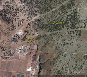
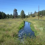
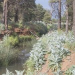
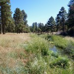
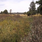
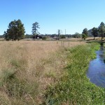
The area that we will look at is the Picture Canyon Meander Restoration Project Phase I & Phase II along the Rio de Flag. In 2009, this area received funding to restore the fluvial processes of the Rio de Flag and to enhance the riparian corridor for habitat, recreation, and aesthetics in the Picture Canyon area. Objectives included restoring channel meander and floodplain function, eliminating noxious weeds, restoring riparian and wetland plant communities, increasing plant species diversity, creating additional wetland habitats, improving water quality, increasing wildlife habitat, and providing recreational benefits.
At this site we will talk about the restoration work, how the community has been involved and have a demonstration of tools that are being used to assess this riparian area project.
- Measure channel cross sections
- Tools: Survey-grade GPS and laser-level
- Measure channel width and depth and compare with previous cross section measurements to determine aggradation or degradation within the channel.
- Vegetation monitoring
- Tools: GPS, sample grid, survey tape
- Identify plant species within sample grid to determine species present. Species will inform whether the system is increasing or decreasing in presence of native species and if additional vegetation management controls need to be implemented.
- Photo monitoring
- Tools: Digital camera, compass, GPS
- Digital photos are taken typically from a permanently marked location to show how a feature or landscape changes over time.
- Using tablets to identify vegetation patches
- Tools: Tablets, GPS
- Holding a tablet, areas of vegetation are walked to identify patch size so the area can be mapped. Maps are used in planning were to prioritize project areas.
Background information on Rio de Flag Stream Restoration Project
The Rio de Flag (RDF) is the primary watercourse winding through Flagstaff, Arizona. The stream channel is ephemeral or intermittent depending on the season or local geology. Picture Canyon is located on the east side of Flagstaff along the RDF.
Sometime in the past, the stream channel above and below Picture Canyon was dredged and straightened, removing a number of natural meanders. This channelization was likely done to rapidly remove effluent released from the Wildcat Hills Waste Water Treatment Plant. The dredged and straightened section had no access to its floodplain and supported a very limited riparian plant community. Noxious weeds invaded the site due to the soil disturbance from the trenching activities. The result was a significant narrowing of the riparian area and a rapid transit of the perennial stream flow, effectively reducing riparian and wetland habitat.
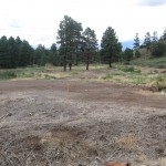
Water quality of releases from the wastewater treatment plant were vastley improved due to technology upgrades and there is no longer a need to rapidly remove the released water from the site. The goal of the project was to restore the fluvial processes of the stream and enhance the riparian corridor for habitat, recreation, and aesthetics. Specific objectives included: eliminate noxious weeds, restore channel meander and floodplain function, restore native riparian and wetland plant communities, increase plant species diversity, create additional wetland habitats, improve water quality, increase wildlife habitat, provide recreation and aesthetic benefits, and demonstrate and educate the general public of the restoration methods. The riparian and wetland area have roughly doubled in size from 2 to 5 acres.
The improved riparian, aesthetic and recreational values of the property in addition to the significant cultural resources associated with the site have led the City of Flagstaff to purchase the property and manage it as a natural and cultural resource preserve.
Before and After Photos of the Rio de Flag Restoration Project (courtesy of Allen Haden, Natural Channel Design)
Some Hotels in the Area
Drury Inn & Suites
300 South Milton Road
Flagstaff, AZ 86001
928-773-4900
Highland Country Inn
223 S. Milton Rd
Flagstaff, AZ 86001
928-774-5041
Rodeway Inn Downtown
122 West Route 66
Flagstaff, AZ 86001
1-800-470-3709
Travelodge Flagstaff
1560 E. Route 66
Flagstaff, AZ 86001
928-774-7186
America’s Best Inn
910 South Milton Road
Flagstaff, AZ 86001
Hotel: 928-774-7171
Reservations:800-237-8466
Econo Lodge
914 S. Milton Rd.
Flagstaff, AZ, 86001-6386
Phone: (928) 774-7326
Embassy Suites Flagstaff
706 South Milton Road
Flagstaff, AZ 8600
928-774-4333